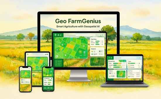





Smart Agriculture with Geospatial AI

Smart Agriculture with Geospatial AI

How Farmers Use AI and Satellite Insights to Maximize Crop Yield and Reduce Risk

Read Case StudyContact Us

Faster Crop Health Detection

40%

Reduction in Water Waste

30%

Increase in Yield Forecast Accuracy

100%

Land Coverage Visibility

Client Overview

An agri-tech enterprise set out to help farmers optimize crop yield using satellite data. Traditional field inspections were slow, inconsistent, and dependent on manual labor and weather conditions.

The client’s goal was to build a geospatial AI platform that could detect crop health issues, monitor land changes, and forecast yields, remotely and in real time, with minimal farmer intervention.

The Challenges

Farmers and agronomists faced several major obstacles in their daily operations:

Limited Field Visibility

On-ground monitoring was time-consuming and lacked full-coverage accuracy.

Unpredictable Weather Risks

Delayed detection of drought, flooding, or pests impacted crops heavily.

Inefficient Water Use

Lack of real-time soil and vegetation insights led to overwatering or drought stress.

Manual Yield Forecasting

Planning decisions were based on guesswork instead of hard data.

The client needed a solution that provided real-time, actionable insights using satellite imagery and AI accessible even in remote or low-connectivity areas.

Our AI‑Driven Solution

We developed a geospatial data analysis system powered by machine learning, and satellite imaging. The platform delivers real-time insights to farmers for better decision-making.

AI Crop Health Monitoring

  • Processes satellite images (NDVI, thermal, multispectral) to detect stress early
  • Identifies pest, disease, and nutrient-related issues before they escalate

Smart Irrigation Optimization

  • AI models estimate soil moisture and evapotranspiration levels
  • Farmers receive zone-specific irrigation recommendations

Geospatial Yield Forecasting Engine

  • Combines historical weather, land use, and crop cycle data
  • Generates field-level yield predictions to guide input planning and logistics

The Results

Our platform brought data-driven clarity to agricultural management at scale:

5× faster detection of crop anomalies

5× faster detection of crop anomalies

Farmers took early action on disease, pest, and water issues.

Water use reduced by 40% through precision irrigation

Water use reduced by 40% through precision irrigation

Smarter watering led to healthier crops and cost savings.

30% improvement in forecast accuracy

30% improvement in forecast accuracy

Better input planning and resource allocation boosted profits.

Full coverage of large agricultural zones

Full coverage of large agricultural zones

From small plots to industrial farms, every field was tracked.

Technology Used

Tech Stack We Used

To deliver a scalable and reliable agriculture-focused geospatial platform, we leveraged cutting-edge AI and satellite technologies.

Geospatial Satellite Imaging

Processed NDVI, Sentinel, and Landsat datasets for vegetation monitoring.

Machine Learning Models

Trained for crop classification, moisture prediction, and yield estimation.

Image Processing & Computer Vision

Used deep learning (CNN) for anomaly detection in satellite images.

Cloud Infrastructure (AWS)

Ensured high availability and seamless data integration across zones.

Interactive Farmer Dashboard

Delivered map overlays, forecasts, and alerts in a mobile-friendly interface.

Offline Sync & Edge Support

Enabled data access and action even in low-connectivity areas.

Conclusion

Success Story

AI-Powered Farming for Smarter, Sustainable Growth

The client’s geospatial platform helped farmers monitor crops, optimize resources, and improve planning, resulting in healthier yields and more sustainable operations.

Faster Stress Detection

Faster Stress Detection

Act on early warnings from satellite data

Water & Input Efficiency

Water & Input Efficiency

Save resources through precision recommendations

Smarter Seasonal Planning

Smarter Seasonal Planning

Use AI forecasts for timely decisions

92%

Client Satisfaction

38%

Input Cost Reduction

100%

Remote Land Monitoring Coverage

Want to power agriculture with AI and satellite insights?

Let’s build a scalable geospatial solution for smart farming. Our AI & data science experts are ready to help.

Contact UsRequest Demo

Have a question or need a custom quote

Our in-depth understanding in technology and innovation can turn your aspiration into a business reality.

1
Have a free technical consultation
2
Sign your NDA
3
Get connected to our tech team
4
Get our team onboard for you

      Connect With US

      x